
ߞߐߕߐ߮:Eastern Front Kharkov Vicinity 1941-06 to 1941-12.png
ߢߊߓߐߣߍ߲ ߛߊ߲ߘߐߕߊ߫ ߜߘߍ߫ ߕߍ߫ ߦߋ߲߬
Eastern_Front_Kharkov_Vicinity_1941-06_to_1941-12.png (߃߀߀ × ߂߄߈ ߖߌ߬ߦߊ߬ߘߊ߲ߕߊ߸ ߞߐߕߐ߮ ߢߊ߲ߞߊ߲: ߃߅ KB߸ MIME ߛߎ߮ߦߊ:image/png)

|
ߓߊߓߌߟߊߟߌ ߟߊߘߌ߬ߢߍ߬ ߣߍ߲߫߸ ߞߵߊ߬ ߘߐߕߟߊ߫ ߊ߬ ߣߌ߫/ߥߟߊ߫ ߞߊ߬ ߘߐ߬ߛߙߋ ߣߌ߲߬ ߡߊߦߟߍ߬ߡߊ߲߫ ߛߙߊߕߌ ߣߌ߲߬ ߠߊ߫ GNU Free Documentation License, ߡߊ߬ߦߟߍ߬ߡߊ߲߬ߣߠߌ߲ ߁.߂ ߥߟߊ߫ ߡߊ߬ߦߟߍ߬ߡߊ߲߬ߠߌ߲ ߜߘߍ ߛߎ߯-ߎ߯-ߛߎ߫ ߟߊߥߊ߲߬ߞߊ߫ ߣߍ߲߫ Free Software Foundation; ߓߟߏ߫, ߕߍߕߍ߯ ߞߕߐߡߊߛߊ߬ߦߌ߲߬ߣߍ߲ ߝߋ߲߫ ߕߍ߫߸ ߊ߬ ߞߣߐߟߊ ߥߣߊ߬ߙߌ߬ ߛߓߍߟߌ߫ ߕߍ߫߸ ߊ߬ ߣߌ߫ ߞߐߞߊ߲߫ ߥߣߊߙߌ ߛߓߍߟߌ߫ ߕߍ߫.ߊ߬ ߓߊߞߎߘߊ ߕߌ߰ߦߊ ߟߊߘߏ߲߬ߣߍ߲߬ ߦߋ߫ ߕߍߕߍ߮ ߣߌ߲߬ ߠߋ ߘߐ߫߸ ߞߴߊ߬ ߕߐ߯ߟߊ߫ ߞߏ߫ GNU Free Documentation License. |
| ߞߐߕߐ߮ ߣߌ߲߬ ߦߋ߫ ߞߍߦߙߐ ߣߌ߲߬ ߠߎ߬ Creative Commons Attribution-Share Alike 3.0 Unported ߟߊ߫ ߘߌ߬ߢߍ ߟߋ߬ ߘߐ߫ | ||
same or compatible license ߊ߬ ߛߎ߲ ߘߌ߫. | ||
| This licensing tag was added to this file as part of the GFDL licensing update. |
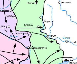
English: Eastern front of the Second World War in the vicinity of Kharkov and Belgorod. A possibly useful 300-pixel-wide map for the first battle of Kharkov.
- Pink area is captured by Germans up to September 1st 1941
- Purple area is captured by Germans up to September 9th 1941
- Green area is captured by Germans up to December 5th 1941
Русский: Карта боевых действий на Восточной Украине, осень 1941 года. Цветом обозначены захваченные Германией территории:
- Розовый — к 1 сентября;
- Фиолетовый — к 9 сентября;
- Зелёный — к 5 декабря.
Cropped from Image:Eastern Front 1941-06 to 1941-12.png [1].
![[1]](https://upload.wikimedia.org/wikipedia/commons/b/b8/Eastern_Front_1941-06_to_1941-12.png)
derivative works
Derivative works of this file: Fronte Meridionale dal 1941-06 al 1941-12.png
ߞߐߕߐ߮ ߟߊ߫ ߘߐ߬ߝߐ
ߕߎ߬ߡߊ߬ߘߊ/ߕߎ߬ߡߊ ߛߐ߲߬ߞߌ߲߬ ߓߊ߫߸ ߞߊ߬ ߕߎ߬ߡߊ߬ߘߊ ߞߐߕߐ߮ ߟߎ߬ ߦߋ߫.
| ߕߎ߬ߡߊ߬ߘߊ/ߕߎ߬ߡߊ߬ߟߊ߲ | ߞߝߊ߬ߟߋ߲ߛߋ߲ | ߛߎߡߊ߲ߘߐ | ߟߊ߬ߓߊ߰ߙߊ߬ߟߊ | ߞߊ߲߬ߝߐߟߌ | |
|---|---|---|---|---|---|
| ߞߍߛߊ߲ߞߏ | ߂߂:߂߄, ߂ ߞߏ߲ߞߏߜߍ ߂߀߀߆ | | ߃߀߀ × ߂߄߈ (߃߅ KB) | Hautala | {{GFDL}} Eastern front of the Second World War in the vicinity of Kharkov and Belgorod. A possibly useful 300-pixel-wide map for the first battle of Kharkov. :Pink area is captured by Germans up to September 1st 1941 :Purple area is captured by Germans u |
ߞߐߕߐ߮ ߟߊߓߊ߯ߙߊߟߌ
ߞߐߜߍ߫ ߛߌ߫ ߡߊ߫ ߞߐߕߐ߮ ߣߌ߲߬ ߠߊߓߊ߯ߙߊ߫ ߡߎߣߎ߲߬
ߞߐߕߐ߮ ߟߊߓߊ߯ߙߊߟߌ߫ ߞߙߎߞߙߍ
ߥߞߌ߫ ߕߐ߭ ߢߌ߲߬ ߠߎ߬ ߦߋ߫ ߞߐߕߐ߮ ߣߌ߲߬ ߠߊߓߊ߯ߙߊ߫ ߟߊ߫:
- ߊ߬ ߟߊߓߊ߯ߙߊ߫ et.wikipedia.org ߘߐ߫
- ߊ߬ ߟߊߓߊ߯ߙߊ߫ fi.wikipedia.org ߘߐ߫
- ߊ߬ ߟߊߓߊ߯ߙߊ߫ fr.wikipedia.org ߘߐ߫
- ߊ߬ ߟߊߓߊ߯ߙߊ߫ he.wikipedia.org ߘߐ߫
- ߊ߬ ߟߊߓߊ߯ߙߊ߫ it.wikipedia.org ߘߐ߫
- ߊ߬ ߟߊߓߊ߯ߙߊ߫ vi.wikipedia.org ߘߐ߫