
ߞߐߕߐ߮:CAN orthographic.svg

ߣߌ߲߬ PNG ߢߊ߲ߞߊ߲߸ ߣߌ߲߬ SVG ߢߍߦߋߟߌ߸ ߞߐߕߐ߮: ߔߌߞߑߛߍߟ ߅߅߁ × ߅߅߁ ߢߊߓߐߟߌ ߟߎ߬ ߕߐ߬ߡߊ ߔߌߞߑߛߍߟ ߂߄߀ × ߂߄߀ | ߔߌߞߑߛߍߟ ߄߈߀ × ߄߈߀ | ߔߌߞߑߛߍߟ ߇߆߈ × ߇߆߈ | ߔߌߞߑߛߍߟ ߁,߀߂߄ × ߁,߀߂߄ | ߔߌߞߑߛߍߟ ߂,߀߄߈ × ߂,߀߄߈.
ߞߐߕߐ߮ ߓߊߛߎ߲ (SVG ߞߐߕߐ߮, ߕߐ߯ߦߊߟߌ ߅߅߁ × ߅߅߁ ߖߌ߬ߦߊ߬ߘߊ߲ߕߊ, ߞߐߕߐ߮ ߢߊ߲ߞߊ߲: ߁.߈߃ MB)
ߟߊߘߛߏߣߍ߲
| ߕߐ߯ߟߊߘߏ߲ |
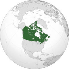
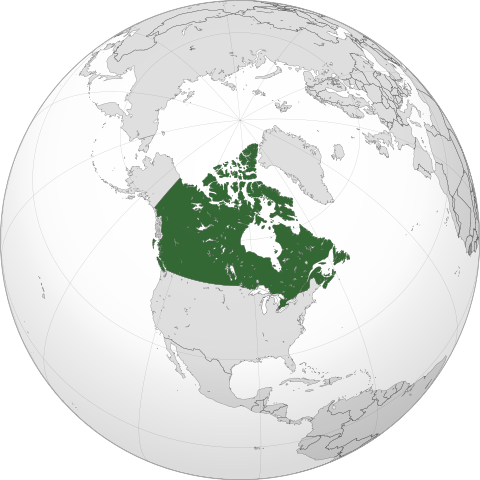
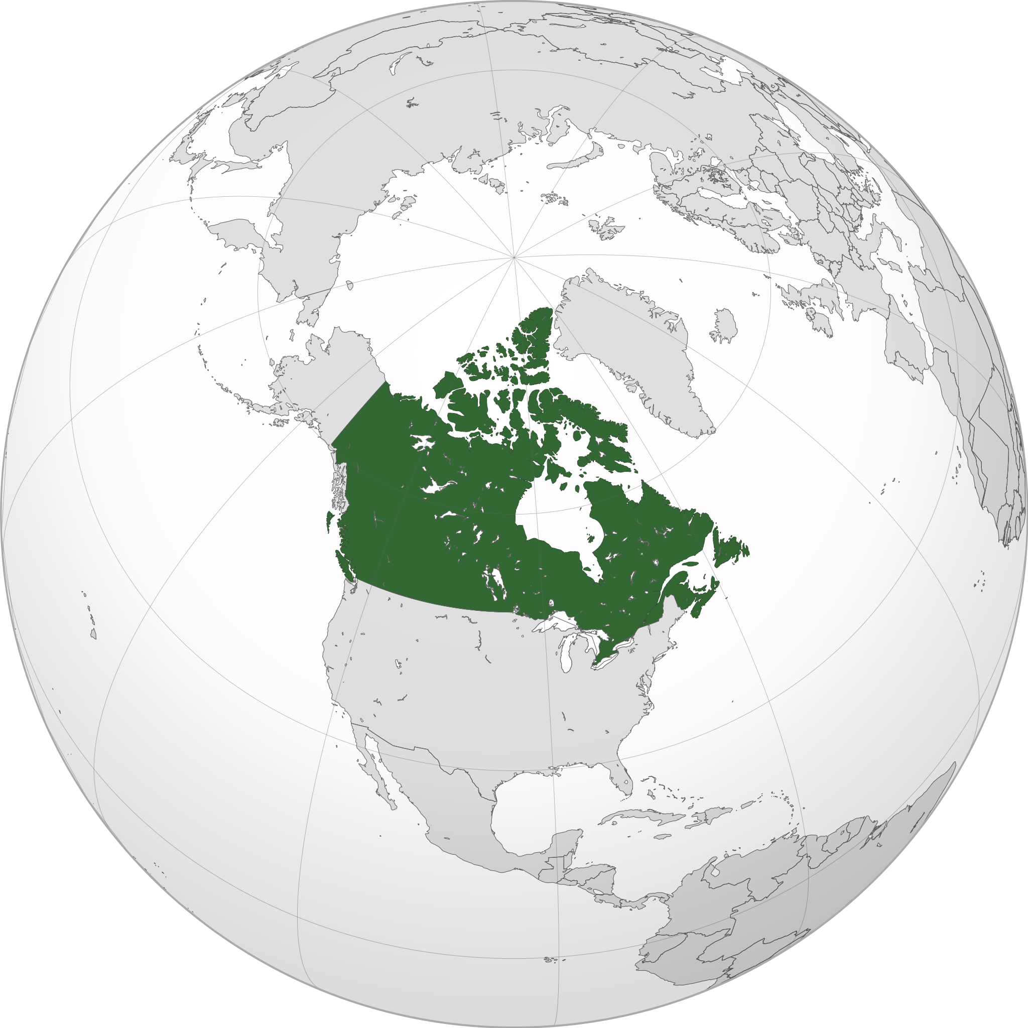
English: A map of the hemisphere centred on -95, 60, using an orthographic projection, created using gringer's Perl script with Natural Earth Data (1:50000 resolution, simplified to 0.25px). Canada is highlighted in green.
Official territory. Claimed territories. |
| ߕߎ߬ߡߊ߬ߘߊ | |
| ߛߎ߲ | ߟߊ߫ ߓߊ߯ߙߊ ߟߋ߫ ߘߌ߫ with Natural Earth Data |
| ߛߓߍߦߟߊ | Addicted04 |
| SVG genesis |
.svg)
.svg)
.svg)
.svg)
.svg)
.svg)
.svg)
.svg)
.svg)
.svg)
.svg)
.svg)
.svg)
.svg)
.svg)
.svg)
.svg)
.svg)
.svg)
.svg)
.svg)
.svg)
.svg)
.svg)
.svg)
.svg)
.svg)
.svg)
.svg)
.svg)
.svg)
.svg)
.svg)
.svg)
.svg)
.svg)
.svg)
.svg)
.svg)
.svg)
.svg)
.svg)
.svg)
.svg)
.svg)
.svg)
.svg)
.svg)
.svg)
.svg)
.svg)
.svg)
.svg)
.svg)
.svg)
.svg)
.svg)
.svg)
.svg)
.svg)
.svg)
.svg)
.svg)
.svg)
.svg)
.svg)
.svg)
.svg)
.svg)
.svg)
.svg)
.svg)
.svg)
.svg)

.svg)

.svg)

.svg)
.svg)
.svg)
.svg)
.svg)
.svg)
.svg)


.svg)
.svg)
.svg)
.svg)
.svg)
.svg)
.svg)

.svg)
.svg)
.svg)
.svg)
.svg)
.svg)
.svg)
.svg)
.svg)
.svg)

.svg)
.svg)
.svg)
.svg)
.svg)
.svg)
.svg)
_without_national_boundaries.svg)
.svg)
.svg)
.svg)
.svg)
.svg)
.svg)

.svg)
.svg)
.png)
.svg)
.svg)
.svg)
.svg)

.svg)
.svg)
.svg)
.svg)
.svg)
.svg)
.svg)
.svg)
.svg)
.svg)
.svg)

.svg)
.svg)
.svg)
.svg)
.svg)
.svg)
.svg)
.svg)
.svg)

.svg)
.svg)

.svg)
.svg)
.svg)
.svg)
.svg)
.svg)
.svg)
.svg)
.svg)
.svg)
.svg)
.svg)
.svg)
.svg)
.svg)
.svg)
.svg)
.svg)
.svg)
.svg)
.svg)
.svg)
.svg)
.svg)
.svg)
.svg)
.svg)
_-_Crimea_disputed.svg)
.svg)
.svg)
.svg)
.svg)
.svg)
.svg)
.svg)
.svg)
.svg)
.svg)
.svg)
_political.svg)
.svg)
.svg)
.svg)
.svg)
_-_Crimea_disputed_-_no_borders.svg)
.svg)
.svg)
.svg)
.svg)
.svg)
.svg)
.svg)
.svg)
.svg)
.svg)
.svg)

.svg)
.svg)
.svg)

.png)
.svg)
.svg)
.svg)
.svg)
.svg)
.svg)
.svg)
.svg)
.svg)
.svg)
.svg)
.svg)
.svg)
.svg)
.svg)
.svg)
.svg)
.svg)
.svg)
.svg)
.svg)
.svg)
.svg)
.svg)
.svg)
.svg)
.svg)
.svg)
.svg)
.svg)
.svg)
.svg)
.svg)
.svg)
.png)
.svg)
.svg)
.svg)
_(orthographic_projection).png)
| Orthographic projections maps created by Ssolbergj |
|---|
| Orthographic projections maps created by Ssolbergj: |
.svg)
.svg)
ߟߊ߬ߘߌ߬ߢߍ߬ߟߌ ߦߴߌ ߘߐ߫
I, the copyright holder of this work, hereby publish it under the following license:
ߞߐߕߐ߮ ߣߌ߲߬ ߦߋ߫ ߞߍߦߙߐ ߣߌ߲߬ ߠߎ߬ Creative Commons Attribution-Share Alike 3.0 Unported ߟߊ߫ ߘߌ߬ߢߍ ߟߋ߬ ߘߐ߫
- ߌ ߞߊ߲ߠߊߓߌ߬ߟߊ߬ߣߍ߲߫
- ߞߵߊ߬ ߟߊߖߍ߲ߛߍ߲߫ – ߞߊ߬ ߓߊ߯ߙߊ ߓߊߞߎߘߦߊ߫߸ ߞߴߊ߬ ߘߐߝߘߊ߫߸ ߊ߬ ߣߌ߫ ߞߵߊ߬ ߟߊߕߊ߬ߡߌ߲߬
- ߞߵߊ߬ ߢߣߊߓߊ߬ߛߊ߲߬ ߕߎ߲߯ – ߞߊ߬ ߓߊ߯ߙߊ ߟߊߘߏ߲߬
- ߓߍ߲߬ߒߡߊ߬ߞߊ߲߫ ߣߊ߬ߕߐ ߢߌ߲߬ ߠߎ߬ ߟߊ߫:
- ߘߎ߲߬ߘߎ߬ߡߊ߬ߦߊ – ߌ ߦߋ߫ ߞߍߕߊ ߓߍ߲߬ߣߍ߲ ߠߊߘߏ߲߬߸ ߞߊ߬ ߟߊ߬ߘߌ߬ߢߍ߬ߟߌ ߛߘߌ߬ߜߋ߲ ߘߏ߫ ߡߊߛߐ߫߸ ߊ߬ ߣߌ߫ ߞߊ߬ ߞߐ߯ߙߍߦߊ߫ ߣߌ߫ ߡߊ߬ߦߟߍ߬ߡߊ߲߬ߠߌ߲ ߞߍߣߍ߲߫ ߞߍ߫ ߘߊ߫. ߌ ߦߴߏ߬ ߞߍ߫ ߞߍߢߊ߫ ߟߊߘߌ߬ߢߍ߬ߣߍ߲ ߓߍ߯ ߡߊ߬߸ ߞߏ߬ߣߌ߲߬ ߢߊ ߓߍ߯ ߡߊ߬ ߞߏ߫ ߕߍ߫ ߘߋ߬߸ ߡߍ߲ ߘߌ߫ ߛߋ߫ ߟߊ߬ߘߌ߬ߢߍ߬ߟߊ ߘߐߛߎ߫ ߟߴߌ ߞߊ߲ߛߏ߲߫ ߡߊ߬߸ ߥߟߊ߫ ߌ ߟߊ߫ ߟߊ߬ߓߊ߰ߙߊߟߊ.
- ߘߍ߬ߒ߬ߡߊ߬ ߝߋ߲ – ߣߴߌ ߞߵߊ߬ ߡߊߦߟߍ߬ߡߊ߲߫߸ ߖߙߎߡߎ߲ ߦߟߍ߬ߡߊ߲߫߸ ߥߟߊ߫ ߞߵߊ߬ ߓߊ߯ߙߊ ߓߐ߬ߓߐ ߣߌ߲߬ ߞߊ߲߬߸ ߌ ߞߍߕߐ߫ ߦߋ߫ ߞߐߖߋߓߌ߫ ߞߋߟߋ߲߫ ߠߋ߬ ߘߐߝߘߊ߫ ߟߊ߫ ߥߟߊ߫ ߌ ߟߊ߫ ߡߊ߬ߜߍ߲ ߞߍ߫ ߕߐ߫ ߦߋ߫
ߞߐߕߐ߮ ߟߊ߫ ߘߐ߬ߝߐ
ߕߎ߬ߡߊ߬ߘߊ/ߕߎ߬ߡߊ ߛߐ߲߬ߞߌ߲߬ ߓߊ߫߸ ߞߊ߬ ߕߎ߬ߡߊ߬ߘߊ ߞߐߕߐ߮ ߟߎ߬ ߦߋ߫.
| ߕߎ߬ߡߊ߬ߘߊ/ߕߎ߬ߡߊ߬ߟߊ߲ | ߞߝߊ߬ߟߋ߲ߛߋ߲ | ߛߎߡߊ߲ߘߐ | ߟߊ߬ߓߊ߰ߙߊ߬ߟߊ | ߞߊ߲߬ߝߐߟߌ | |
|---|---|---|---|---|---|
| ߞߍߛߊ߲ߞߏ | ߀߀:߀߅, ߁߉ ߓߌ߲ߠߊߥߎߟߋ߲ ߂߀߁߄ | | ߅߅߁ × ߅߅߁ (߁.߈߃ MB) | Addicted04 | New map |
| ߂߁:߃߇, ߁߉ ߕߎߟߊߝߌ߲ ߂߀߁߁ |  | ߅߅߀ × ߅߅߀ (߁.߃߁ MB) | Addicted04 | Western islands | |
| ߀߁:߂߉, ߁߉ ߕߎߟߊߝߌ߲ ߂߀߁߁ |  | ߅߅߀ × ߅߅߀ (߁.߃߁ MB) | Addicted04 |
ߞߐߕߐ߮ ߟߊߓߊ߯ߙߊߟߌ
ߞߐߜߍ߫ ߛߌ߫ ߡߊ߫ ߞߐߕߐ߮ ߣߌ߲߬ ߠߊߓߊ߯ߙߊ߫ ߡߎߣߎ߲߬
ߞߐߕߐ߮ ߟߊߓߊ߯ߙߊߟߌ߫ ߞߙߎߞߙߍ
ߥߞߌ߫ ߕߐ߭ ߢߌ߲߬ ߠߎ߬ ߦߋ߫ ߞߐߕߐ߮ ߣߌ߲߬ ߠߊߓߊ߯ߙߊ߫ ߟߊ߫:
- ߊ߬ ߟߊߓߊ߯ߙߊ߫ am.wikipedia.org ߘߐ߫
- ߊ߬ ߟߊߓߊ߯ߙߊ߫ ar.wikipedia.org ߘߐ߫
- كندا
- مستخدم:وهراني/ملعب
- مستخدم:جار الله/قائمة صور مقالات العلاقات الثنائية
- العلاقات الأنغولية الكندية
- العلاقات الكندية الكورية الجنوبية
- العلاقات الإريترية الكندية
- العلاقات السويسرية الكندية
- العلاقات الألمانية الكندية
- العلاقات الكندية الليختنشتانية
- العلاقات البوليفية الكندية
- العلاقات الكندية الموزمبيقية
- العلاقات الألبانية الكندية
- العلاقات البلجيكية الكندية
- العلاقات الإثيوبية الكندية
- العلاقات البيلاروسية الكندية
- العلاقات الطاجيكستانية الكندية
- العلاقات الروسية الكندية
- العلاقات الرومانية الكندية
- العلاقات الأرجنتينية الكندية
- العلاقات الغامبية الكندية
- العلاقات القبرصية الكندية
- العلاقات السيراليونية الكندية
- العلاقات الكندية النيبالية
- العلاقات الكندية الليبيرية
- العلاقات التشيكية الكندية
- العلاقات الكندية الميانمارية
- العلاقات الزيمبابوية الكندية
- العلاقات الإسرائيلية الكندية
- العلاقات البالاوية الكندية
- العلاقات الكندية النيجيرية
- العلاقات اليمنية الكندية
- العلاقات الفانواتية الكندية
- العلاقات الغابونية الكندية
- العلاقات البنمية الكندية
- العلاقات الكندية الكوبية
- العلاقات الجورجية الكندية
- العلاقات التونسية الكندية
- العلاقات الكندية الكورية الشمالية
- العلاقات الهندية الكندية
- العلاقات الإيطالية الكندية
- العلاقات الكندية الناوروية
- العلاقات الأسترالية الكندية
- العلاقات الزامبية الكندية
- العلاقات الفيجية الكندية
- العلاقات المارشالية الكندية
- العلاقات الأذربيجانية الكندية
- العلاقات السودانية الكندية
- العلاقات الكويتية الكندية
- العلاقات الكندية الكونغوية
ߞߐߕߐ߮ ߣߌ߲߬ more global usage ߦߋߟߌ.