
ߞߐߕߐ߮:Indonesia provinces english.png

ߊ߬ ߢߍߦߋߟߌ ߢߊ߲ߞߊ߲: ߔߌߞߑߛߍߟ ߈߀߀ × ߃߆߅. ߢߊߓߐߟߌ ߟߎ߬ ߕߐ߬ߡߊ ߔߌߞߑߛߍߟ ߃߂߀ × ߁߄߆ | ߔߌߞߑߛߍߟ ߆߄߀ × ߂߉߂ | ߔߌߞߑߛߍߟ ߁,߆߂߈ × ߇߄߂.
ߞߐߕߐ߮ ߓߊߛߎ߲ (߁,߆߂߈ × ߇߄߂ ߖߌ߬ߦߊ߬ߘߊ߲ߕߊ߸ ߞߐߕߐ߮ ߢߊ߲ߞߊ߲: ߉߂ KB߸ MIME ߛߎ߮ߦߊ:image/png)

|
File:Indonesia, administrative divisions - en - monochrome.svg is a vector version of this file. It should be used in place of this PNG file when not inferior.
File:Indonesia provinces english.png → File:Indonesia, administrative divisions - en - monochrome.svg
For more information, see Help:SVG. |
 |

|
This file requires updating because: In 2022, the Papua provinces changed from 2 provinces to 6 provinces. In doing so, you could add a timestamp to the file.
|
ߟߊߘߛߏߣߍ߲
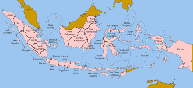
Map of the provinces of Indonesia in English.
Made by User:Golbez based on a PD CIA map, using other sources to guesstimate the extent of West Irian Jaya and West Sulawesi.
derivative works
Derivative works of this file: Indonesia, administrative divisions - en - monochrome.svg
ߟߊ߬ߘߌ߬ߢߍ߬ߟߌ ߦߴߌ ߘߐ߫
I, the copyright holder of this work, hereby publish it under the following licenses:

|
ߓߊߓߌߟߊߟߌ ߟߊߘߌ߬ߢߍ߬ ߣߍ߲߫߸ ߞߵߊ߬ ߘߐߕߟߊ߫ ߊ߬ ߣߌ߫/ߥߟߊ߫ ߞߊ߬ ߘߐ߬ߛߙߋ ߣߌ߲߬ ߡߊߦߟߍ߬ߡߊ߲߫ ߛߙߊߕߌ ߣߌ߲߬ ߠߊ߫ GNU Free Documentation License, ߡߊ߬ߦߟߍ߬ߡߊ߲߬ߣߠߌ߲ ߁.߂ ߥߟߊ߫ ߡߊ߬ߦߟߍ߬ߡߊ߲߬ߠߌ߲ ߜߘߍ ߛߎ߯-ߎ߯-ߛߎ߫ ߟߊߥߊ߲߬ߞߊ߫ ߣߍ߲߫ Free Software Foundation; ߓߟߏ߫, ߕߍߕߍ߯ ߞߕߐߡߊߛߊ߬ߦߌ߲߬ߣߍ߲ ߝߋ߲߫ ߕߍ߫߸ ߊ߬ ߞߣߐߟߊ ߥߣߊ߬ߙߌ߬ ߛߓߍߟߌ߫ ߕߍ߫߸ ߊ߬ ߣߌ߫ ߞߐߞߊ߲߫ ߥߣߊߙߌ ߛߓߍߟߌ߫ ߕߍ߫.ߊ߬ ߓߊߞߎߘߊ ߕߌ߰ߦߊ ߟߊߘߏ߲߬ߣߍ߲߬ ߦߋ߫ ߕߍߕߍ߮ ߣߌ߲߬ ߠߋ ߘߐ߫߸ ߞߴߊ߬ ߕߐ߯ߟߊ߫ ߞߏ߫ GNU Free Documentation License. |
| ߞߐߕߐ߮ ߣߌ߲߬ ߦߋ߫ ߞߍߦߙߐ ߣߌ߲߬ ߠߎ߬ Creative Commons Attribution-Share Alike 3.0 Unported ߟߊ߫ ߘߌ߬ߢߍ ߟߋ߬ ߘߐ߫ | ||
same or compatible license ߊ߬ ߛߎ߲ ߘߌ߫. | ||
| This licensing tag was added to this file as part of the GFDL licensing update. |
This file is licensed under the Creative Commons Attribution 2.5 Generic license.
- ߌ ߞߊ߲ߠߊߓߌ߬ߟߊ߬ߣߍ߲߫
- ߞߵߊ߬ ߟߊߖߍ߲ߛߍ߲߫ – ߞߊ߬ ߓߊ߯ߙߊ ߓߊߞߎߘߦߊ߫߸ ߞߴߊ߬ ߘߐߝߘߊ߫߸ ߊ߬ ߣߌ߫ ߞߵߊ߬ ߟߊߕߊ߬ߡߌ߲߬
- ߞߵߊ߬ ߢߣߊߓߊ߬ߛߊ߲߬ ߕߎ߲߯ – ߞߊ߬ ߓߊ߯ߙߊ ߟߊߘߏ߲߬
- ߓߍ߲߬ߒߡߊ߬ߞߊ߲߫ ߣߊ߬ߕߐ ߢߌ߲߬ ߠߎ߬ ߟߊ߫:
- ߘߎ߲߬ߘߎ߬ߡߊ߬ߦߊ – ߌ ߦߋ߫ ߞߍߕߊ ߓߍ߲߬ߣߍ߲ ߠߊߘߏ߲߬߸ ߞߊ߬ ߟߊ߬ߘߌ߬ߢߍ߬ߟߌ ߛߘߌ߬ߜߋ߲ ߘߏ߫ ߡߊߛߐ߫߸ ߊ߬ ߣߌ߫ ߞߊ߬ ߞߐ߯ߙߍߦߊ߫ ߣߌ߫ ߡߊ߬ߦߟߍ߬ߡߊ߲߬ߠߌ߲ ߞߍߣߍ߲߫ ߞߍ߫ ߘߊ߫. ߌ ߦߴߏ߬ ߞߍ߫ ߞߍߢߊ߫ ߟߊߘߌ߬ߢߍ߬ߣߍ߲ ߓߍ߯ ߡߊ߬߸ ߞߏ߬ߣߌ߲߬ ߢߊ ߓߍ߯ ߡߊ߬ ߞߏ߫ ߕߍ߫ ߘߋ߬߸ ߡߍ߲ ߘߌ߫ ߛߋ߫ ߟߊ߬ߘߌ߬ߢߍ߬ߟߊ ߘߐߛߎ߫ ߟߴߌ ߞߊ߲ߛߏ߲߫ ߡߊ߬߸ ߥߟߊ߫ ߌ ߟߊ߫ ߟߊ߬ߓߊ߰ߙߊߟߊ.
ߌ ߘߌ߫ ߛߴߌ ߘߌߦߊߣߊ߲߫ ߕߦߊ ߛߎߥߊ߲ߘߌ߫ ߟߊ߫
ߞߐߕߐ߮ ߟߊ߫ ߘߐ߬ߝߐ
ߕߎ߬ߡߊ߬ߘߊ/ߕߎ߬ߡߊ ߛߐ߲߬ߞߌ߲߬ ߓߊ߫߸ ߞߊ߬ ߕߎ߬ߡߊ߬ߘߊ ߞߐߕߐ߮ ߟߎ߬ ߦߋ߫.
| ߕߎ߬ߡߊ߬ߘߊ/ߕߎ߬ߡߊ߬ߟߊ߲ | ߞߝߊ߬ߟߋ߲ߛߋ߲ | ߛߎߡߊ߲ߘߐ | ߟߊ߬ߓߊ߰ߙߊ߬ߟߊ | ߞߊ߲߬ߝߐߟߌ | |
|---|---|---|---|---|---|
| ߞߍߛߊ߲ߞߏ | ߁߂:߄߀, ߂߅ ߞߏ߲ߓߌߕߌ߮ ߂߀߂߀ | | ߁,߆߂߈ × ߇߄߂ (߉߂ KB) | Afrogindahood | Addition of North Kalimantan province |
| ߀߇:߅߄, ߈ ߓߌ߲ߠߊߥߎߟߋ߲ ߂߀߀߆ | ߁,߅߀߀ × ߅߉߀ (߇߇ KB) | Golbez | Map of the provinces of Indonesian in English. Made by User:Golbez based on a PD CIA map, using other sources to guesstimate the extent of West Irian Jaya and West Sulawesi. Category:Maps of Indonesia |
ߞߐߕߐ߮ ߟߊߓߊ߯ߙߊߟߌ
ߞߐߜߍ߫ ߛߌ߫ ߡߊ߫ ߞߐߕߐ߮ ߣߌ߲߬ ߠߊߓߊ߯ߙߊ߫ ߡߎߣߎ߲߬
ߞߐߕߐ߮ ߟߊߓߊ߯ߙߊߟߌ߫ ߞߙߎߞߙߍ
ߥߞߌ߫ ߕߐ߭ ߢߌ߲߬ ߠߎ߬ ߦߋ߫ ߞߐߕߐ߮ ߣߌ߲߬ ߠߊߓߊ߯ߙߊ߫ ߟߊ߫:
- ߊ߬ ߟߊߓߊ߯ߙߊ߫ arz.wikipedia.org ߘߐ߫
- ߊ߬ ߟߊߓߊ߯ߙߊ߫ ba.wikipedia.org ߘߐ߫
- ߊ߬ ߟߊߓߊ߯ߙߊ߫ be-tarask.wikipedia.org ߘߐ߫
- ߊ߬ ߟߊߓߊ߯ߙߊ߫ blk.wikipedia.org ߘߐ߫
- ߊ߬ ߟߊߓߊ߯ߙߊ߫ bxr.wikipedia.org ߘߐ߫
- ߊ߬ ߟߊߓߊ߯ߙߊ߫ ca.wikipedia.org ߘߐ߫
- ߊ߬ ߟߊߓߊ߯ߙߊ߫ ceb.wikipedia.org ߘߐ߫
- ߊ߬ ߟߊߓߊ߯ߙߊ߫ crh.wikipedia.org ߘߐ߫
- ߊ߬ ߟߊߓߊ߯ߙߊ߫ csb.wikipedia.org ߘߐ߫
- ߊ߬ ߟߊߓߊ߯ߙߊ߫ cs.wikipedia.org ߘߐ߫
- ߊ߬ ߟߊߓߊ߯ߙߊ߫ cy.wikipedia.org ߘߐ߫
- ߊ߬ ߟߊߓߊ߯ߙߊ߫ da.wikipedia.org ߘߐ߫
- ߊ߬ ߟߊߓߊ߯ߙߊ߫ diq.wikipedia.org ߘߐ߫
- ߊ߬ ߟߊߓߊ߯ߙߊ߫ dv.wikipedia.org ߘߐ߫
- ߊ߬ ߟߊߓߊ߯ߙߊ߫ en.wikipedia.org ߘߐ߫
- ߊ߬ ߟߊߓߊ߯ߙߊ߫ es.wikipedia.org ߘߐ߫
- ߊ߬ ߟߊߓߊ߯ߙߊ߫ fr.wikipedia.org ߘߐ߫
- ߊ߬ ߟߊߓߊ߯ߙߊ߫ gd.wikipedia.org ߘߐ߫
- ߊ߬ ߟߊߓߊ߯ߙߊ߫ gl.wikipedia.org ߘߐ߫
- ߊ߬ ߟߊߓߊ߯ߙߊ߫ ht.wikipedia.org ߘߐ߫
- ߊ߬ ߟߊߓߊ߯ߙߊ߫ hu.wikipedia.org ߘߐ߫
- ߊ߬ ߟߊߓߊ߯ߙߊ߫ incubator.wikimedia.org ߘߐ߫
- ߊ߬ ߟߊߓߊ߯ߙߊ߫ it.wikipedia.org ߘߐ߫
- ߊ߬ ߟߊߓߊ߯ߙߊ߫ ja.wikipedia.org ߘߐ߫
- ߊ߬ ߟߊߓߊ߯ߙߊ߫ kaa.wikipedia.org ߘߐ߫
- ߊ߬ ߟߊߓߊ߯ߙߊ߫ kk.wikipedia.org ߘߐ߫
- ߊ߬ ߟߊߓߊ߯ߙߊ߫ km.wikipedia.org ߘߐ߫
- ߊ߬ ߟߊߓߊ߯ߙߊ߫ kn.wikipedia.org ߘߐ߫
- ߊ߬ ߟߊߓߊ߯ߙߊ߫ kv.wikipedia.org ߘߐ߫
- ߊ߬ ߟߊߓߊ߯ߙߊ߫ kw.wikipedia.org ߘߐ߫
- ߊ߬ ߟߊߓߊ߯ߙߊ߫ lij.wikipedia.org ߘߐ߫
- ߊ߬ ߟߊߓߊ߯ߙߊ߫ lmo.wikipedia.org ߘߐ߫
- ߊ߬ ߟߊߓߊ߯ߙߊ߫ ln.wikipedia.org ߘߐ߫
- ߊ߬ ߟߊߓߊ߯ߙߊ߫ lv.wikipedia.org ߘߐ߫
- ߊ߬ ߟߊߓߊ߯ߙߊ߫ mg.wikipedia.org ߘߐ߫
- ߊ߬ ߟߊߓߊ߯ߙߊ߫ mhr.wikipedia.org ߘߐ߫
- ߊ߬ ߟߊߓߊ߯ߙߊ߫ ml.wikipedia.org ߘߐ߫
- ߊ߬ ߟߊߓߊ߯ߙߊ߫ mn.wikipedia.org ߘߐ߫
- ߊ߬ ߟߊߓߊ߯ߙߊ߫ my.wikipedia.org ߘߐ߫
- ߊ߬ ߟߊߓߊ߯ߙߊ߫ mzn.wikipedia.org ߘߐ߫
- ߊ߬ ߟߊߓߊ߯ߙߊ߫ new.wikipedia.org ߘߐ߫
- ߊ߬ ߟߊߓߊ߯ߙߊ߫ nl.wikipedia.org ߘߐ߫
- ߊ߬ ߟߊߓߊ߯ߙߊ߫ nn.wikipedia.org ߘߐ߫
- ߊ߬ ߟߊߓߊ߯ߙߊ߫ pag.wikipedia.org ߘߐ߫
- ߊ߬ ߟߊߓߊ߯ߙߊ߫ pam.wikipedia.org ߘߐ߫
- ߊ߬ ߟߊߓߊ߯ߙߊ߫ pap.wikipedia.org ߘߐ߫
- ߊ߬ ߟߊߓߊ߯ߙߊ߫ pms.wikipedia.org ߘߐ߫
- ߊ߬ ߟߊߓߊ߯ߙߊ߫ pnb.wikipedia.org ߘߐ߫
ߞߐߕߐ߮ ߣߌ߲߬ more global usage ߦߋߟߌ.