
ߞߐߕߐ߮:Guinea Map.jpg

ߊ߬ ߢߍߦߋߟߌ ߢߊ߲ߞߊ߲: ߔߌߞߑߛߍߟ ߅߁߆ × ߅߉߉. ߢߊߓߐߟߌ ߟߎ߬ ߕߐ߬ߡߊ ߔߌߞߑߛߍߟ ߂߀߇ × ߂߄߀ | ߔߌߞߑߛߍߟ ߄߁߃ × ߄߈߀ | ߔߌߞߑߛߍߟ ߆߆߁ × ߇߆߈ | ߔߌߞߑߛߍߟ ߁,߁߀߄ × ߁,߂߈߂.
ߞߐߕߐ߮ ߓߊߛߎ߲ (߁,߁߀߄ × ߁,߂߈߂ ߖߌ߬ߦߊ߬ߘߊ߲ߕߊ߸ ߞߐߕߐ߮ ߢߊ߲ߞߊ߲: ߂߄߀ KB߸ MIME ߛߎ߮ߦߊ:image/jpeg)
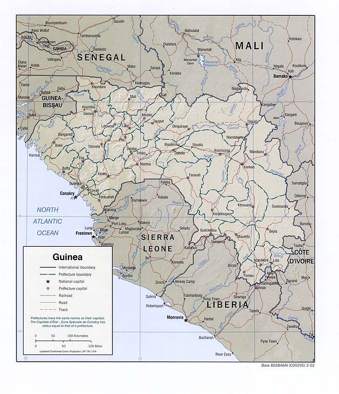
| ߕߐ߯ߟߊߘߏ߲ | Shaded relief map of Guinea. | |||
| ߕߎ߬ߡߊ߬ߘߊ | ||||
| ߛߎ߲ | [1] from the Perry-Castañeda Library Map Collection. | |||
| ߛߓߍߦߟߊ | CIA | |||
| ߘߌ߬ߢߍ߬ߟߊ߬ߢߌ߬ߣߌ߲߬ (ߞߐߕߐ߮ ߣߌ߲߬ ߠߊߓߊ߯ߙߊ߫ ߕߎ߲߯) |
|
|||
| Other versions | Derivative works of this file: Kouroussa prefect Guinea Map.jpg |

![[1]](http://www.lib.utexas.edu/maps/africa/guinea_rel02.jpg)
ߞߐߕߐ߮ ߟߊ߫ ߘߐ߬ߝߐ
ߕߎ߬ߡߊ߬ߘߊ/ߕߎ߬ߡߊ ߛߐ߲߬ߞߌ߲߬ ߓߊ߫߸ ߞߊ߬ ߕߎ߬ߡߊ߬ߘߊ ߞߐߕߐ߮ ߟߎ߬ ߦߋ߫.
| ߕߎ߬ߡߊ߬ߘߊ/ߕߎ߬ߡߊ߬ߟߊ߲ | ߞߝߊ߬ߟߋ߲ߛߋ߲ | ߛߎߡߊ߲ߘߐ | ߟߊ߬ߓߊ߰ߙߊ߬ߟߊ | ߞߊ߲߬ߝߐߟߌ | |
|---|---|---|---|---|---|
| ߞߍߛߊ߲ߞߏ | ߁߃:߁߀, ߂߂ ߞߏ߲ߞߏߜߍ ߂߀߀߆ | | ߁,߁߀߄ × ߁,߂߈߂ (߂߄߀ KB) | Lupo | Shaded relief map of Guinea. Source: [http://www.lib.utexas.edu/maps/africa/guinea_rel02.jpg] from the [http://www.lib.utexas.edu/maps/guinea.html Perry-Castañeda Library Map Collection]. {{PD-USGov-CIA}} Category:Maps of Guinea |
ߞߐߕߐ߮ ߟߊߓߊ߯ߙߊߟߌ
ߞߐߜߍ 1 ߟߎ߬ ߦߋ߫ ߞߐߕߐ߮ ߣߌ߲߬ ߠߊߓߊ߯ߙߊ߫ ߟߊ߫:
ߞߐߕߐ߮ ߟߊߓߊ߯ߙߊߟߌ߫ ߞߙߎߞߙߍ
ߥߞߌ߫ ߕߐ߭ ߢߌ߲߬ ߠߎ߬ ߦߋ߫ ߞߐߕߐ߮ ߣߌ߲߬ ߠߊߓߊ߯ߙߊ߫ ߟߊ߫:
- ߊ߬ ߟߊߓߊ߯ߙߊ߫ cv.wikipedia.org ߘߐ߫
- ߊ߬ ߟߊߓߊ߯ߙߊ߫ en.wikipedia.org ߘߐ߫
- ߊ߬ ߟߊߓߊ߯ߙߊ߫ fi.wikipedia.org ߘߐ߫
- ߊ߬ ߟߊߓߊ߯ߙߊ߫ fr.wikipedia.org ߘߐ߫
- ߊ߬ ߟߊߓߊ߯ߙߊ߫ hr.wiktionary.org ߘߐ߫
- ߊ߬ ߟߊߓߊ߯ߙߊ߫ it.wikipedia.org ߘߐ߫
- ߊ߬ ߟߊߓߊ߯ߙߊ߫ lt.wikipedia.org ߘߐ߫
- ߊ߬ ߟߊߓߊ߯ߙߊ߫ pt.wikipedia.org ߘߐ߫
- ߊ߬ ߟߊߓߊ߯ߙߊ߫ ru.wikipedia.org ߘߐ߫
- ߊ߬ ߟߊߓߊ߯ߙߊ߫ sv.wikipedia.org ߘߐ߫
- ߊ߬ ߟߊߓߊ߯ߙߊ߫ uk.wikipedia.org ߘߐ߫
- ߊ߬ ߟߊߓߊ߯ߙߊ߫ vec.wikipedia.org ߘߐ߫
- ߊ߬ ߟߊߓߊ߯ߙߊ߫ zh.wikipedia.org ߘߐ߫